Who's familiar with the southern portion of HW1? (C7 Conv. + HWY1)
 03-18-2015, 03:53 PM
#1
TECH Enthusiast
Thread Starter
iTrader: (4)
Join Date: Nov 2008
Posts: 517
Likes: 0
Received 0 Likes
on
0 Posts

Planning to rent a C7 convertible in May, leaving out of LA at 9am and staying a night in Santa Barbara. Are there any good roads I need to make sure I hit? I'm willing to travel North of Santa Barbara, as long as I make it back by 7pm for dinner, where I will probably be popping the big question.

 03-18-2015, 07:36 PM
#5
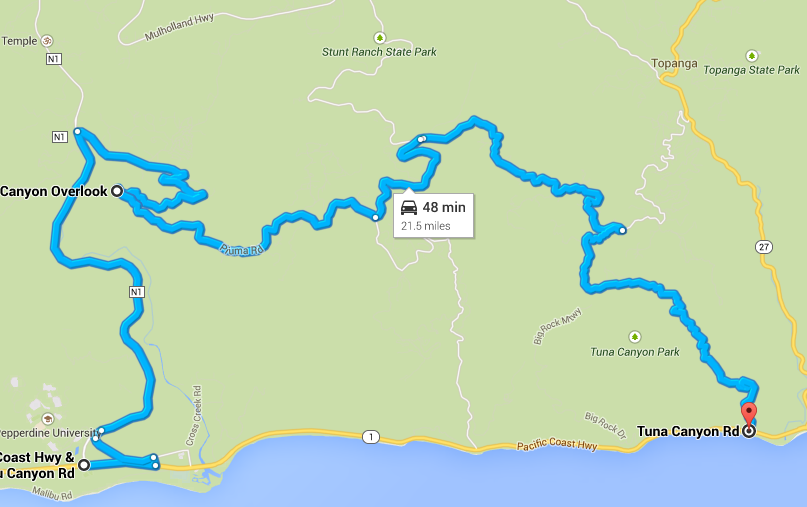
This loop (starting at the northern point) takes you from PCH in Malibu down through Malibu Canyon, then back up into the mountains with an excellent view of the ocean below, plus Malibu from above, then takes you down the mountain via a one-way that's well known for its smooth road surface and nicely banked corners.

There are many others to see if this is too long or if you desire something a little straighter.
03-20-2015, 12:44 PM
#7
TECH Enthusiast
Thread Starter
iTrader: (4)
Join Date: Nov 2008
Posts: 517
Likes: 0
Received 0 Likes
on
0 Posts

This loop (starting at the northern point) takes you from PCH in Malibu down through Malibu Canyon, then back up into the mountains with an excellent view of the ocean below, plus Malibu from above, then takes you down the mountain via a one-way that's well known for its smooth road surface and nicely banked corners.
There are many others to see if this is too long or if you desire something a little straighter.
Will do. Hopefully, they aren't as bad as the cops here in GA. They are everywhere, hiding in every good spot.
Trending Topics
03-21-2015, 08:51 PM
#8
TECH Fanatic
iTrader: (2)

Join Date: Mar 2002
Location: I can drive my F-body in Winter!
Posts: 1,195
Likes: 0
Received 0 Likes
on
0 Posts
I might add there are usually officers patrolling there as they know it is popular with car nuts like us. Also take note they are actually there for a reason, to save your life: the cliffs, something happens, then blam, off the road you go, falling and rolling. Just take note that the sides of the road are usually steep hills. Heck back 40+ years ago Pt Mugu, had a road that circled around a cliff. Many people went off the road, dropping the 10-15 feet to the cold ocean below. It was such a problem, they blasted a new path for the road, thus creating Pt. Mugu Rock as we know it today
Also take note: towards the end of the southern portion of Hwy1, the Springs fire from May 2013 caused several landslides this past winter, closing it for over 1 month. They made sections with 1 lane in direction of travel and jersey barrier with fencing. Beware of falling rock. I at least go to Neptune's, twice a month for lunch from work.
Also note that around noon, during the week, around Pt. mugu they can cause delays to traffic due to filming.
My favorite section is central california from north of Morro Bay, elephant seal beach, to Monterrey. 100 miles of twisties
03-25-2015, 08:37 AM
#9
TECH Enthusiast
Thread Starter
iTrader: (4)
Join Date: Nov 2008
Posts: 517
Likes: 0
Received 0 Likes
on
0 Posts
I might add there are usually officers patrolling there as they know it is popular with car nuts like us. Also take note they are actually there for a reason, to save your life: the cliffs, something happens, then blam, off the road you go, falling and rolling. Just take note that the sides of the road are usually steep hills. Heck back 40+ years ago Pt Mugu, had a road that circled around a cliff. Many people went off the road, dropping the 10-15 feet to the cold ocean below. It was such a problem, they blasted a new path for the road, thus creating Pt. Mugu Rock as we know it today
Also take note: towards the end of the southern portion of Hwy1, the Springs fire from May 2013 caused several landslides this past winter, closing it for over 1 month. They made sections with 1 lane in direction of travel and jersey barrier with fencing. Beware of falling rock. I at least go to Neptune's, twice a month for lunch from work.
Also note that around noon, during the week, around Pt. mugu they can cause delays to traffic due to filming.
My favorite section is central california from north of Morro Bay, elephant seal beach, to Monterrey. 100 miles of twisties
And I wish I had enough time to head that far North! Looks like a fun route!
Does anyone know of any remarkable scenic vantage points to stop at along the way or near my route from LA to Santa Barbara? I'm thinking about having the GoPro mounted on the vette, taking pictures at 2 second intervals, and I pull of the road and get out to propose with everything being captured.